

Interactive World Maps
An interactive HTML5 map plugin is a one-stop solution if you need to give your visitors a simple yet efficient way to browse around regional portions of your site. Additionally, if you want to deliver some information to your visitors that is related to geography, an interactive HTML5 map plugin is also an option. You are able to display a map of the world by only inserting a shortcode into the primary body of a web page or blog post thanks to the plugin. The map can be used in a matter of minutes because it allows for the visual adjustment of its parameters and has an installation process that is very simple.
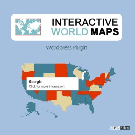
Show Different Regions
You will have the ability to display hundreds of distinct types of maps, all of which are already included:
- A map that covers the whole planet.
- A continent or a sub-continent. (Africa, Europe, Americas, Asia, Oceania and all their sub-continents)
- A nation-state. (almost every nation on earth is represented, including some of the most popular destinations: the United States of America, the United Kingdom of Great Britain and Northern Ireland, Canada, France, Germany, Spain, Italy, Brazil, India, and Australia…)
- A nation that is subdivided into its several regions.
- One of the states that make up the United States.
- The United States of America broken up into its several urban areas.
- In the United States, a state that is broken up into its several urban areas.
Color Regions or add Markers
On the map, you have the option of adding active coloured regions, and you can display them in one of two ways:
- When applied to regions, the colour will permeate the entirety of the territory, whether it be a continent, a subcontinent, a country, a country province, or a state in the United States.
- As Markers – It will display a coloured bubble in the chosen regions, which can be a city, a state, or a country. These regions can be anything from one city to an entire country.
Customizable
You will be able to costumize the visual of your maps:
- Background color;
- Box border width and color;
- Inactive regions color;
- Individual colors for each active region;
- Markers size;
- Width and Height of the map;
Add the Maps anywhere on your website
You can incorporate the maps in posts, pages, and even in widgets that are located in the sidebar by using a shortcode. A straightforward PHP function can be used to incorporate the maps into your template as well.
Responsive
It will load with the maximum width that is available in the container div if no width is given for it. For instance, it will load and adapt to various sizes for devices such as phones, tablets, and laptops. Despite this, even if you resize the window after it has been loaded, it will not change size.
Since version 1.4, the plugin has included a setting that gives users the opportunity to make their maps entirely responsive. This will utilise jQuery to determine if the window size has changed, and if it has, it will redraw the map to make advantage of the new space that is available.
Cross device and browser compatible
The maps are produced in SVG, and as flash is not utilised in their creation, Mac products will be able to display them.
CSS Hacks made easy
There are a few capabilities that the Google Geochart API does not give by default; nevertheless, the plugin provides a ‘Custom CSS Generator’ to assist in the implementation of these features, such as the implementation of a hover colour change effect, the implementation of typeface icons as markers, and the changing of the colour of the border.
Features
- Interactive map of the World
- Responsive and mobile-friendly
- SVG based
- Works on iOS/Android devices
- Popup windows that show when the mouse cursor is over it
- Customizable landing page links
- Easy embedding by a shortcode


Jack (verified owner) –